

Pete Curran, Watch Duty's staff meteorologist, joined Chuck Todd for a broad-ranging discussion about Watch Duty's mission, the state of extreme weather risks in 2026, the ever-growing wildfire season, and how you can prepare for extreme weather conditions before emergency strikes.
Watch the full interview below, or listen to Pete's episode of the Chuck ToddCast on your preferred podcast app.

Wildfires are growing faster, more complex, and more destructive. The ability to detect and communicate critical information in seconds rather than minutes has become a life-safety issue for communities and first responders. Today, Google.org announced it is deploying a Google.org Fellowship to support Watch Duty, embedding Google engineers within the organization to help build AI infrastructure that accelerates emergency alerts at scale.
Through the Google.org Fellowship, Google engineers will work directly alongside Watch Duty’s team to develop AI systems that monitor live emergency radio traffic, surface critical signals faster, and support - not replace - human decision-making, ensuring our team can assess and verify information more efficiently while reducing the time it takes to alert the public during wildfires.
“Speed matters in emergencies,” said John Mills, CEO and co-founder of Watch Duty. “We’ve built a nonprofit that leverages the best talent and infrastructure in service of communities. The Google.org Fellowship will accelerate this work using Google Gemini so that life-saving information reaches people faster.”
Fire radio traffic frequently carries the earliest indications of new ignitions, evacuation orders, and changes in fire behavior, but it is fragmented across thousands of analog channels and difficult to scale through human monitoring alone. Watch Duty’s trained reporters currently listen live to hundreds of publicly available radio streams, often switching between dozens of open emergency response channels during a single incident. In Los Angeles County alone, a major wildfire can require monitoring more than 20 radio frequencies at once.
To address this bottleneck, the Google.org Fellowship is helping Watch Duty to:
“Watch Duty represents the best of what technology can do when driven by purpose,” said Brian Juhyuk Lee, Sustainability Giving Lead at Google.org. “It’s a privilege to support the Watch Duty mission and team — whether that means answering a call in the middle of the night or deploying our top engineers to help solve complex AI challenges. We’re proud to support their mission to democratize access to vital information.”
The Google.org Fellowship builds on broader, multi-year support for Watch Duty, grounded in shared concern about urgency, speed, and operational reliability during crises.
In 2024, Google.org provided Watch Duty with multi-year $2 million funding, combining funding with pro bono technical and capacity support to help the organization scale nationally. Watch Duty also operates across Google’s technology ecosystem, using tools such as Google Workspace, Firebase, and Google Gemini to support its engineering, data processing, and internal collaboration as demand continues to grow. Gemini also helps the Watch Duty team quickly parse Public Information Officer (PIO) updates across formats like email and PDFs, and supports image filtering for user-submitted photos, prioritizing those that contain relevant signals such as smoke or fire. Watch Duty is part of the AI Collaborative: Wildfires, facilitated by Google.org, a cross-sector initiative bringing together leading nonprofits, academic institutions, government agencies and companies to help people and communities better manage fires by using AI.
Google’s support proved critical during the Los Angeles wildfires in 2025, when Watch Duty experienced unprecedented demand as millions of people relied on the platform for real-time updates. As conditions evolved rapidly and system load surged, Google’s Firebase team provided technical assistance to Watch Duty in response to the exponential use of their product and services, enabling Watch Duty to remain online, stable, and responsive throughout peak usage.
New capability connects field operations with public information, helping agencies share verified updates faster during rapidly evolving emergencies.
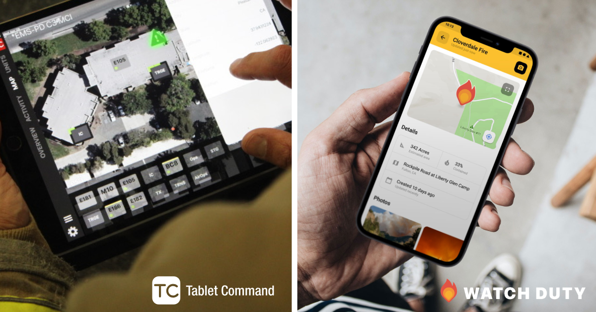
Watch Duty and Tablet Command are joining forces via an upcoming integration that will combine Watch Duty’s real-time, verified emergency information resource with Tablet Command’s premier incident management and response platform.
Through this integration, agencies using Tablet Command will be able to quickly send updates directly from within the Tablet Command platform to the Watch Duty operations team. When an agency chooses to do so, basic incident information can be shared early in the response, giving Watch Duty reporters a critical head start in notifying the public and providing situational awareness during rapidly evolving events.
Emergency responders often manage incidents in one system while communities search for reliable updates in another. This integration closes that gap—allowing agencies to share confirmed information quickly while maintaining full control over what is released and when.
“I founded Watch Duty to help residents understand what was happening around them during wildfires,” said John Mills, cofounder and CEO of Watch Duty. “What we quickly saw was that clear, reliable information helped everyone involved. It added critical value to firefighters as well, while easing their burden and letting them stay focused on the job in front of them. This integration will make it easier for public safety agencies to share information with the communities they serve.”
The capability reflects growing demand from fire service leaders, emergency managers, and dispatch centers for clearer, more coordinated communication during fast-moving events.
“Public safety agencies already manage incidents inside Tablet Command,” said William Pigeon, CEO & Co-Founder of Tablet Command. “This integration gives them the ability to quickly share the right information at the right time with the public through Watch Duty—if and when they choose to do so. Agencies remain fully in control of what is shared, but now they have a faster path to keep their communities informed.”
Key benefits of the integration include:
Watch Duty currently serves more than 16 million people annually across all 50 states, delivering real-time alerts and incident reporting sourced from trained personnel and verified data, and Tablet Command supports 1,500 agencies and 60,000 public safety professionals across the United States and Canada, providing tools that help agencies manage incidents, coordinate resources, and support command decisions in the field.
The integration will be available to Tablet Command agencies beginning this spring.

This was the year that propelled Watch Duty onto the national stage, and fortunately, we were prepared to meet the moment. What began four years ago as a small community project that focused on rural communities became a lifeline overnight when catastrophic wildfires ignited on January 7th in Los Angeles, California.
As the LA fires spread, the government alerts and contracted software vendors crashed, Watch Duty maintained 100% uptime and supported 8MM users while sustaining 100,000 requests per second with just a small team of engineers. Our radio operators were sleeping in shifts while we DoorDash’ed them food and provided mental health services from BetterHelp to ensure they were supported and cared for. We worked in close coordination with trusted partners including Google, Fastly, Heroku, Amazon AWS, Mapbox, and our other cloud providers around the clock, to make sure we could sustain the extreme traffic we were experiencing. Donors showed up with nearly $3MM in January alone, reflecting a groundswell of belief in Watch Duty’s mission and impact. The nation showed up for us, just as we did for them.
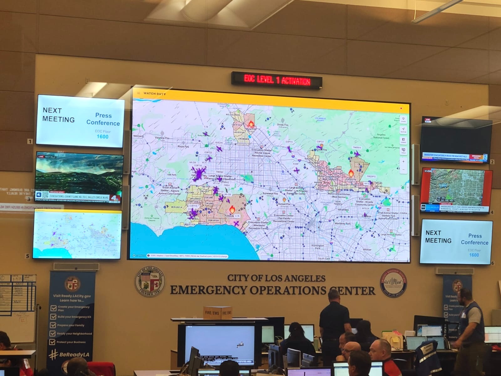
Whether you lived in or near Los Angeles, were monitoring friends and family from afar, or were part of the emergency response, Watch Duty quickly became the trusted source that people and professionals turned to for real-time, life-saving information. At our core, we remain a community-driven nonprofit — but our community is bigger and stronger than ever.
As of a result of the heroic efforts of the entire team, we were named Fast Company’s #1 non-profit, TIME’s 100 Most Innovative Companies, and received Apple’s prestigious Design Award for Social Impact. We also received national recognition from outlets such as the Los Angeles Times (x2), New York Times, Rolling Stone, Newsweek, PBS, WIRED, and countless others, including memes and TV shows.
While we are proud of the recognition we received for our team's efforts, our communities are still in danger, and we must continue to scale rapidly. In fact, in the wake of the LA fires, it was revealed to the world what we already knew – emergency alerting systems are crumbling at an accelerating rate. Damning reports from the McCrystal Group’s After Action Report revealed critical missteps from the emergency alert vendor responsible. Just recently, another competing vendor's system was recently breached so badly that it was deemed unrecoverable with no immediate replacement, leaving communities vulnerable. As if things couldn’t get any worse, private equity is making its way into the public safety software sector and raising prices while limiting product development.
These events further reinforce the need for Watch Duty, not only in the American West, but across the nation. As of December 1st 2025, we expanded our wildfire coverage across all 50 states. Our operations, product, and engineering teams made a herculean effort to deliver this coverage, and they are already developing our flooding product slated to launch this year. We are witnessing similar death tolls across all perils, like the Texas floods in July, due to similar failures in bureaucratic processes and vendors with the same story. We must continue to expand into all-hazards until we finally have a national emergency alert system to keep our country safe – so that communities everywhere can rely on timely, trusted information.
To achieve these goals we more than doubled our headcount across the board starting with our executive staff – adding leaders in impact, communications, public safety, sales, and business operations. We also added 6 more engineers for a total of 10 (up 2.5x), 15 more paid staff reporters for a total of 26 (up 2.3x), recruited 113 new volunteers for a total of 292 (up 1.6x), and the product team grew from 1 to 3 (up 3x). We are scaling carefully and sustainably to meet growing demand.
In total we currently have 48 paid staff, 42 full-time and 6 seasonal reporters. We are growing at an ambitious but manageable pace, not only financially but across onboarding, training, and culture. We operate with a blended funding model that combines philanthropic donations, revenue through enterprise sales, and app memberships. This revenue fuels our ability to deliver life-saving services at no-cost to anyone who downloads Watch Duty from the app store.
In 2025 we had a $6MM budget, and as of Dec 31st, we have $7.6MM in the bank, generated $5.58MM from memberships, and received $5.63MM in grants and donations for a total of $11.4MM (up 2x). This is due in a large part to the LA Fires but our professional offering is really starting to take off, which helps our free service operations.
In 2026, we budgeted for $13.3MM in spend and ambitiously forecast $8MM in ARR and $9MM in donations, at a minimum. Our sales and impact teams are new this year, and we just turned on our marketing engine in November, a new function of the business. Up until this point we have solely relied on product-led growth, so we expect positive changes in the forecast in H2 2026.
Our budget includes the new business units, though the bulk is allocated primarily to operations, product, and engineering, which represents our core non-profit program. We have been doubling headcount significantly across all of these functions, and operations continue to be the largest with 26 paid staff and 292 volunteers.
As we continue to cover more landmass and dive deeper into other hazards, we will need more reporters as well as new areas of expertise. Operations has already stood up a volunteer team of meteorologists with new areas of experience being added constantly. Overall, the operations team has done a great job sourcing, onboarding, and training. We are only limited by recruiting, which continues to grow as we gain more notoriety.
Product and engineering will have their hands full in 2026, not only building out new hazards starting with flooding, but supporting reporter operations as well as professional users. If you recall last year’s end of year report, we had hoped to begin work on flooding in January of 2025 but the tragic events in Los Angeles presented an urgent need to change course and focus on doing what we do best – wildfire intelligence. It’s an honor to be afforded the grace to chart our own course, to serve our community, and make decisions that help the greater good. This was absolutely the right decision for the company, and we are happy that we were able to focus on meeting the moment to help the residents of Los Angeles during their most destructive wildfires in their history.
Regardless of our decision to build out flooding in 2026, 2025 was another successful year for the Watch Duty products growth. Yearly active users climbed to 16.8MM (up 2.3x), pageviews jumped to 1.17B from 512MM (up 2.3x), and our basic membership grew to 111,124 (up 2x). First responders from the fire service to power, water, and light are also coming on board in droves with 24,099 professional memberships, up from last year's 3,500 (up 6.8x). In total, we have 135,223 members accounting for 84% of our total annual budget for 2025 (up 4% from last year). We take our growth among users of all levels as more than vanity metrics and more than revenue - this is the greatest source of validation of the value we provide our wider community.
In addition to adding new hazards, we are spending a great deal of time upgrading our tooling, automations, and AI to help our team of radio operators and reporters hear more and see farther. Every alert we send is written by a human. Our reporters are on duty 24/7 looking out for our community, and we strongly believe that having a human in the loop is not just important — it would frankly be dangerous to rely on automations completely. That said, we are investing heavily in technology to help our team hear more and see farther. AI is helping us detect smoke and fire from images, prase PDFs and emails sent from officials, and leverage a speech-to-text radio transcription service currently being developed for us by a team of Google Fellows. All of this technology is in service to our reporters — helping them sift and sort information so they can focus on the signal, not the noise.
On the professional side, our hypothesis that our customers need better tools, not just better data, is proving correct. Customers such as PG&E, Xcel, Verizon, BNSF Railway, Orange County Fire, and others want to overlay their data into our tool, not the other way around. Since launching this tier barely six months ago, we have closed $1MM in ARR ($1.8MM TCV) with a pipeline of $1.4MM and growing fast. In total, our Professional Teams offering accounts for 11,970 of the 24,099 total professional memberships sold.
Just a few years ago, we naively assumed that professionals had the tools they needed, liked, and most importantly, had democratized across their organization. Now, we see all the silos, point solutions, and lackluster products for what they are, and we have the opportunity to continue to simplify and combine. We took this same approach for the consumer market with the mantra of “closing one more browser tab” – now it’s working for the enterprise.
In addition to becoming an indispensable tool for first responders, we are also helping the disaster response industry as a whole through collaborations allowing our partners to reach our mutual customers. On the sciences and non-profit side, we have partnered with UC San Diego’s WIFIRE program and Pyregence to display their fire progression models to first responders. We also partnered with PulsePoint to strengthen cross-platform emergency alerting, enabling their nationwide network of responders and app users to access Watch Duty’s real-time vegetation fire intelligence when it matters most.
On the utility side, we partnered with Overstory who monitors vegetation encroachment over power lines via satellite allowing utilities to better see and manage their infrastructure. Their customers can consume their data directly in Watch Duty, the tool they already know and love.
For the second responders who help with recovery and response, we worked with the Red Cross, World Central Kitchen, Direct Relief and many others who are providing food, medical supplies, and shelter for the displaced communities during times of crisis. We have more planned with Direct Relief and others in 2026.
And finally, to cap off a big year of collaborations, we announced a partnership with Ring that allows Ring users to be alerted of a fire via their app and gives them the opportunity to share their camera images directly with Watch Duty. Should the camera owner opt-in, the world will see a never-seen-before street level view of what’s really happening on the ground, for not only for neighbors, but for first responders.
We firmly believe that solidarity saves lives and that acting together in partnership is the only way to make substantive change. Whether for-profit or non-profit partners, we are here to be of service and if we can help those organizations thrive, we will also thrive.
This year will be the year that we lean heavily into storytelling, not just about us, but our partners, our agencies, and the communities that we serve. Their voices tell the story of us, the story of ‘we’, and stories of hope. We must act together if we are going to overcome the challenges that are facing our communities. To do so, we have set aside a healthy $1MM budget and an executive to head this department so that our communities know that we are here when they need us.
All of these efforts, across product, operations, engineering, and marketing will allow for sales and impact to hit a healthy combined goal of $18.5MM while supporting our communities and our customers. Philanthropic support remains a critical driver of this work, enabling us to serve and reach more people with free, life-saving services while fueling expansion and continued innovation. Now that we have doubled our coverage area and are adding floods, our opportunity only grows. For our commercial offering, this means a whole new set of customers, as well as more value for existing customers, further consolidating tooling.
Annual Note: As a 501(c)(3) non-profit organization, it is our legal obligation to publish much of our accounting as part of the tax code, but that only tells part of the story. We feel as though we can do better and share more about how our organization works; not just for donor transparency but for others who work at non-profits or are thinking about starting one. We are proud of our novel approach, and since we are supported by our members and donors, we think full transparency is the right thing to do. Transparency builds trust, and trust is the cornerstone of our organization – from the top to the bottom.
Below, you can see our accounting broken down in a few different ways to help demonstrate our efficiency as an organization. Our year-over-year budget is available publicly if you’d like to see the raw data (Please Note: Our current year’s financials are unaudited and are subject to change after our Form 990 is filed).
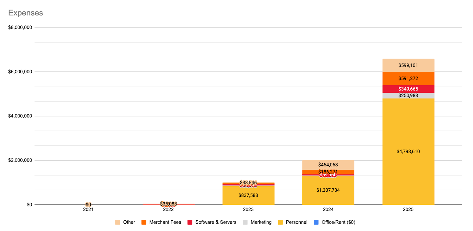
Our people are our service. Without the reporter, engineers, and product teams there would be no alerts. As a result, personnel is by far our largest investment. Borrowing from the software industry, our goal is to keep all other costs as low as possible and pay competitive wages for all of our employees. We have no need for an office nor fancy travel expenses. We need as much of our budget as possible to go to top-tier talent that could otherwise work elsewhere for twice the compensation.
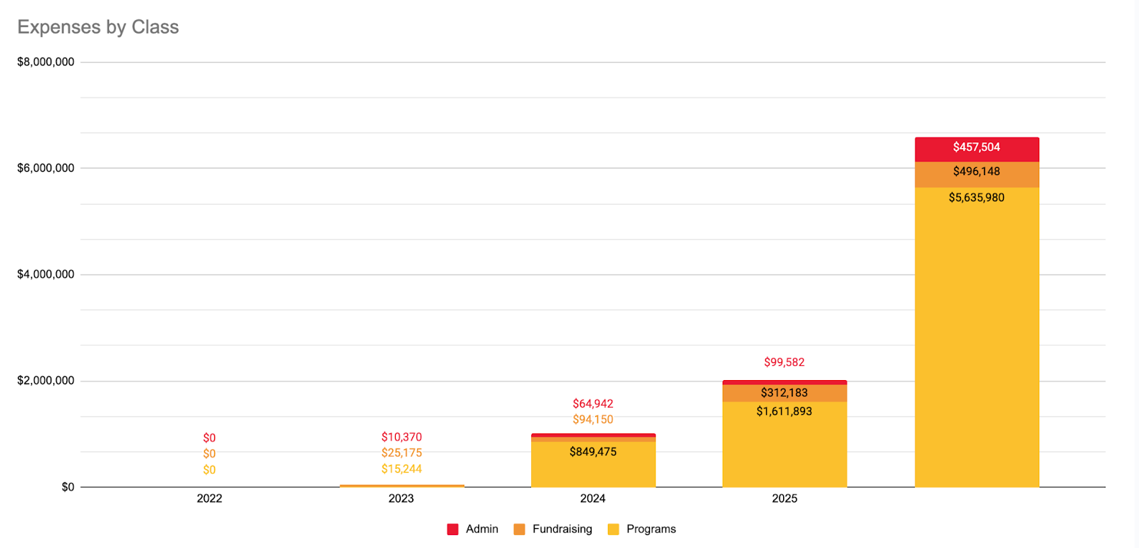
Our employees represent the core of our program, and therefore that is where we want to direct as much capital as possible. Looking at the same data by class (below), you can see just how capital efficient we are with an admin ratio of just 6.94%, up just 2 points from last year. With a non-profit industry standard of around ~35% we are operating at an extremely high efficiency. Over the coming years, we expect that number to rise slightly but we are still targeting to be well under the industry standard.
In terms of measurable impact, this year we were able to serve 16.8 million people directly (1.17 billion page views) and countless others who receive our information from friends, officials, and other news sources who rely on us. First responders and emergency managers alike have asked us to share our pageview analytics so that they can better understand our reach and decide how best to partner with us. Today, we are proud to share those unaudited page view analytics in the hopes that radical transparency will continue to allow more partnerships to flourish.
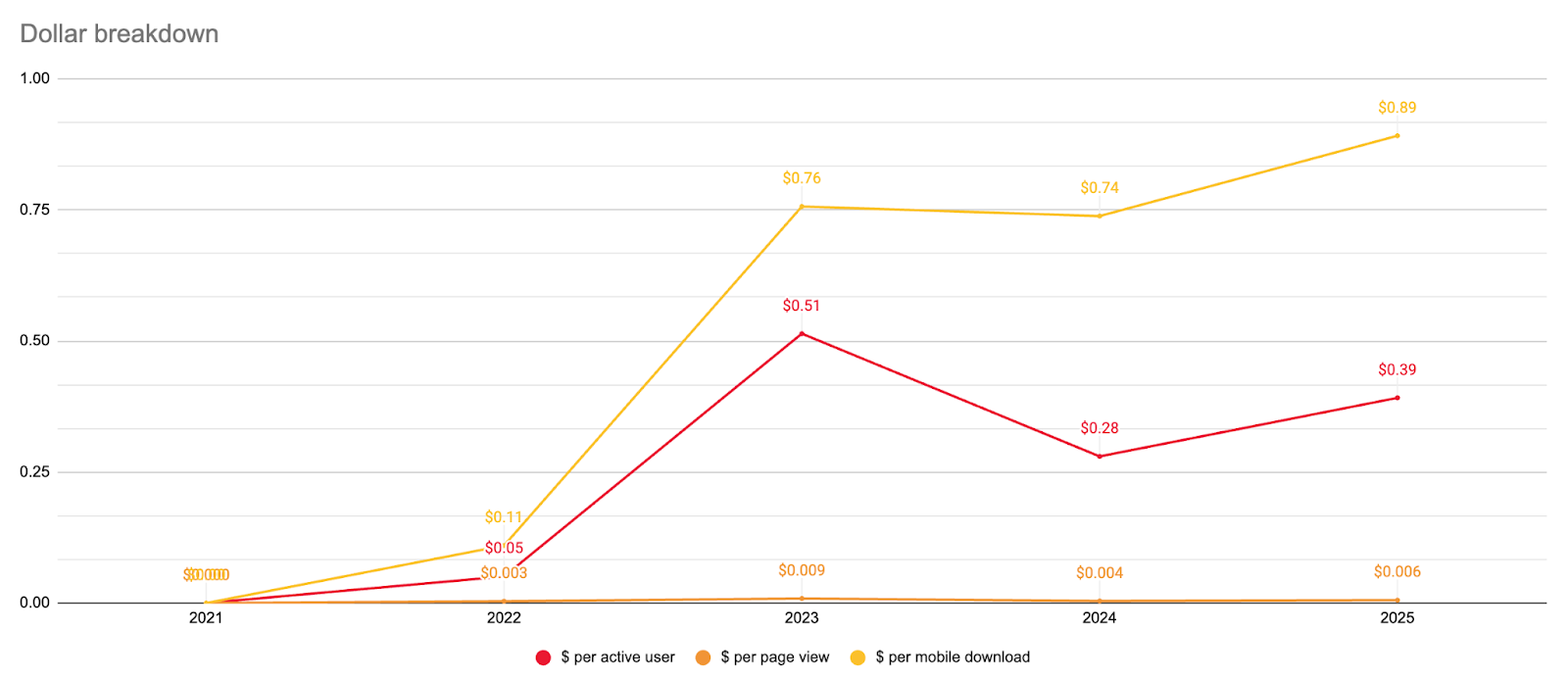
In that same vein, now that our budget and viewership analytics have been quantified and shared publicly, we are able to tabulate our efficiency as a non-profit organization. This is something we are incredibly proud of and is made possible by free open source software, cloud compute, and our talented team of engineers and volunteers. As you can see from the graph below, our cost per user is just $0.39, up from $0.28 last year. We’re committed to stewarding your donation and membership dollars directly to people who may be having the worst day of their lives, with minimal overhead costs.
We’re at a pivotal moment. In the wake of rapid growth, we’re taking this opportunity to fortify our operations, upgrade our product and services, and prepare for yet another ambitious year. Similar to the past several years, our goals are straightforward:
While the first two goals have been on the roadmap for the past year, the third pillar is something we are avidly focusing on as we’ve doubled in size very quickly with more staff on the way. As we prepare for 2027 and our inevitable international expansion, we’ll have to build out twice the amount of scaffolding to support this many people.
To achieve these goals, we have charted out five strategic priorities that will bring us forward to meet the challenges of tomorrow:
1. Serve as a go-to safety tool for as many households as possible
We’re working to make Watch Duty as ubiquitous as any phone app: something everyone has before disaster strikes. We believe that lives can be saved if people are aware in advance of the next wildfire. To do that, we’re launching public education campaigns, strategic partnerships, and community outreach, especially in places too often left behind.
2. Fortify our foundation and invest in the future
As we grow, so must the foundation and systems that support us. We’re strengthening our legal, HR, finance, and operational infrastructure to ensure Watch Duty remains resilient, efficient, and accountable at scale. We’re also ideating and exploring new mission-aligned innovations to prepare for tomorrow’s disasters and community impact funds to immediately and directly support the communities and first responders today.
3. Support and sustain our people
Our team of staff, volunteers, and fire reporters are Watch Duty’s beating heart. We’re strengthening support systems, improving workflows, and investing in training, retention, and well-being to keep our people healthy, motivated, and effective.
4. Build a sustainable, mission-aligned revenue model
We’re blending mission-aligned philanthropy with enterprise partnerships to fuel long-term impact. From diversifying donors to scaling enterprise tools and modernizing how people can give, we’re building a revenue engine that can fuel our mission growth.
5. Accelerate product development, growth, and automation
To meet growth demands, we’re advancing our product and engineering systems by adding more AI tooling, automating workflows, and expanding disaster-specific features for residents and first responders, all while ensuring quality and accuracy through human intervention. The goal is to serve faster, smarter, and at scale.
Watch Duty continues to be extremely successful and impactful to the safety and sanity of millions of people at a cost that only a first-of-its-kind no
n-profit can do. We can attract and retain world-class talent, develop cutting edge products, all while creating deep partnerships across both public and private organizations to help the industry forward.
Most importantly, we have the distinct pleasure of protecting lives and strengthening communities while changing the world for the better. It is truly an honor to serve you, our friends, neighbors, and the community at large.
Thank you for allowing us to serve and to fulfill our purpose. Onward into 2026!
Sources
Today marks one year since the LA wildfires, a moment that resonated far beyond California. From the first alert to the long journey to rebuild, we'll be there to continue to support our neighbors.